Location and Access
The Santa Barbara Property represents the northernmost uranium-mineralized area identified along a NW-SE trend of airborne radiometric anomalies that continues through the Anit and Ivana properties to the south, in central Rio Negro Province. The property has year-round access through a well-maintained gravel road network, and is in a semi-arid topographical depression area with low rainfall and very low population density.
Discovery History
The Santa Barbara property was the initial uranium discovery made by Blue Sky in 2007 and provided the impetus for the Company to undertake the initial airborne radiometric survey. Uranium mineralization at Santa Barbara is directly related to three parallel airborne radiometric anomalies measuring 11 kilometres, 6.5 kilometres and 5 kilometres in length and up to 1.5 kilometres in width. Pitting in the anomalous zones located surficial uranium-vanadium mineralization at depths up to two metres. Additional field work included the 2010 detailed airborne survey, radon gas and spectrometer surveys, pit sampling, and auger and rock sampling. Several zones of flat-lying near-surface mineralization were delineated with yellow carnotite-bearing mineralization. Significant results range from 0.1 to 0.24% U3O8.
The first reverse circulation (“RC”) drilling program was completed in 2017. Fifteen holes were drilled ranging from 4 to 25 metres depth, for a total of 312 metres. No significant zones of uranium-vanadium were identified by the drill program.
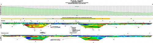
Local Geology
The main uranium mineralization recognized to date is related to NE-SW structural lineaments within Late Cretaceous sediments. These sediments show evidence of alteration processes indicating late reducing/oxidizing events. The presence of elongated radiometric anomalies and high-chargeability anomalies at depth are interpreted as potentially being related to blind uranium sandstone-hosted mineralization and the source of leaking uranium along fractures up to surface.
Unlike the other properties, there is only minor mineralization related to scarce outcrops of the Middle Tertiary unit, the Chinchinales formation. Carnotite coats grains in sand and gravel.
For additional details on the Santa Barbara Property, please refer to the 2012 Technical Report and filings on SEDAR.
 View High Res PDF Version