Location and Tenure
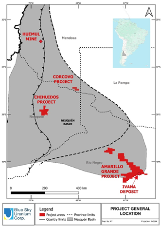
The Corcovo Project is comprised of two adjacent exploration properties totalling approximately 20,000 ha at the northeastern edge of the Neuquén basin. The project is in Mendoza province, within the Western Malargüe Mining District (“MDMO”). The government of Mendoza has launched a vehicle to support development in the province, with a particular focus on mining as a key to both the clean energy transition and growth of local economies (www.impulsamendoza.com.ar). Within this vehicle, the MDMO has been studied and identified as a region very suitable for mining development due to high geological potential and low competition for land or water use. The result is an initiative to speed up and de-bureaucratize procedures for project approvals.
The Corcovo option agreement includes the right to acquire a 100% interest in both tenures under the following terms:
- Payment of US$400,000 in 5 installments over 3 years.
- A 1% NSR payable to the vendor, on both properties, which Blue Sky has the right to buy back for a total of US$500,000.
- A payment of US$500,000 to the vendor if the project achieves commercial production.
Geology
The Neuquén basin is comprised of a +7,000m thick marine and continental sedimentary sequence formed in the Upper Triassic to Middle Tertiary periods. The basin is recognized for its conventional and unconventional oil and gas resources and production. Uranium occurrences are present at different stratigraphic levels throughout the basin. The known occurrences are related to Cretaceous red-beds, such as: the historical uranium-copper-vanadium producing mines of Huemul and Agua Botada to the north in Mendoza province; the Rahue-Co, Cerro Mesa, Campesino Norte and Las Carceles uranium-copper-vanadium occurrences in the central region in Neuquén province; and the new uranium-vanadium Amarillo Grande district discovered by Blue Sky in 2006 to the south, in Rio Negro province. More recently, the presence of uranium mineralization was identified to the east, in La Pampa province, the same region where the Corcovo project is located in the adjacent area of Mendoza province.
The Corcovo Project covers a flat area at the southernmost edge of a Quaternary volcanic plateau situated approximately 600 metres above sea level. This plateau overlays older sequences of the Neuquén Basin. In this region, the geological formation creates a natural trap for hydrocarbons, which migrated from central basin through porous sandstone horizons or “carriers”. This hydrocarbon migration may represent the oxidation-reduction front required for uranium accumulation, potentially forming economic deposits. The presence of lacustrine shales, which overlay the sandstone units, acts as barrier, preventing the migration of hydrocarbons and uranium.
Discovery History
The hydrocarbon migration model was initially recognized by CNEA and followed by a pioneer exploration team prospecting uranium mineralization throughout the Neuquén basin using O&G borehole radiometric data, acquired from Argentine government public databases, as a vectoring prospecting tool. Those surveys exposed uranium anomalies at the Corcovo area associated with the unconformity between Cretaceous units, (Rayoso and Neuquén groups) which are found at depths from 200m to 600m below surface. The presence of uranium anomalies related to high-porosity units, sealed by fine sediments, represents prospective geological conditions for exploring for uranium deposits amenable to In-Situ Recovery (“ISR”).
The World Nuclear Association summarizes the process of ISR mining (also known as solution mining or in situ leaching (“ISL”) as “leaving the ore where it is in the ground, and recovering the minerals from it by dissolving them and pumping the pregnant solution to the surface where the minerals can be recovered. Consequently, there is little surface disturbance and no tailings or waste rock generated.”
To use ISR techniques, the mineralization needs to be hosted within a confined aquifer formed by permeable sediments, like sandstones, sealed above and below by impermeable layers like claystone. These layers confine the native groundwater, which is naturally elevated in uranium and other metals, and precipitation of the minerals can occur. The mining procedures injects an agent, in most cases an oxidant, and uses the same native groundwater to oxidize and re-dissolve the uranium. Once in solution, the uranium is pumped to the surface and recovered in a resin/polymer ion exchange or liquid ion exchange (solvent extraction) system. The final product is a uranium precipitate usually known as yellowcake.
