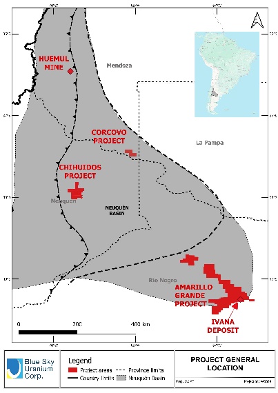
Location and Tenure
The Chihuidos project is comprised of six exploration property units totaling almost 60,000 hectares which are 100% controlled by Blue Sky and were acquired by staking. These cover the core zone of the O&G producing Neuquén basin. The Chihuidos project covers a topographic high surrounded by airborne radiometric anomalies to the north and to the east previously detected by Calypso Uranium Corp. and related to uranium occurrences known as Cerro Mesa and Las Carceles. The project is located 60km west of Añelo city, considered the capital of the unconventional gas production in Argentina.
Geology
The Neuquén basin is comprised of a +7,000m thick marine and continental sedimentary sequence formed in the Upper Triassic to Middle Tertiary periods. The basin is recognized for its conventional and unconventional oil and gas resources and production. Uranium occurrences are present at different stratigraphic levels throughout the basin. The known occurrences are related to Cretaceous red-beds, such as: the historical uranium-copper-vanadium producing mines of Huemul and Agua Botada to the north in Mendoza province; the Rahue-Co, Cerro Mesa, Campesino Norte and Las Carceles uranium-copper-vanadium occurrences in the central region in Neuquén province; and the new uranium-vanadium Amarillo Grande district discovered by Blue Sky in 2006 to the south, in Rio Negro province. More recently, the presence of uranium mineralization was identified to the east, in La Pampa province.
The Chihuidos Project is situated in a low mountain range (~1300 metres above sea level) comprised of a sequence of asymmetrical folded sediments, gently dipping to the east. The erosive windows Cerro Mesa and Las Carceles (~850 masl) to the east and north expose the uranium occurrences related to Cretaceous continental sediments of the Rayoso and Neuquén Groups. Within these units, the uranium mineralization is observed as lenses or tabular bodies hosted by channel-fill sandstones and fine conglomerates, interbedded between fine sediments. The mineralization is associated in both Groups with bleaching alteration, commonly 6 to 10m thick, and associated with organic matter or bitumen, representing the reductant required for uranium precipitation. Radiometric anomalies are also detected at depth in many of the O&G wells drilled in the area.
Discovery Potential
The exploration potential of this project is related to demonstrating continuity at depth of the uranium occurrences and airborne radiometric anomalies present on surface at the topographic lows surrounding the project. Those mineralized horizons are expected to be found as preserved uranium systems at depth, within gently-dipping permeable sandstone and limited by impermeable claystone or siltstones, also providing the basic required conditions for uranium deposits amenable to In-Situ Recovery (“ISR”).
The World Nuclear Association summarizes the process of ISR mining (also known as solution mining or in situ leaching (“ISL”) as “leaving the ore where it is in the ground, and recovering the minerals from it by dissolving them and pumping the pregnant solution to the surface where the minerals can be recovered. Consequently, there is little surface disturbance and no tailings or waste rock generated.”
To use ISR techniques, the mineralization needs to be hosted within a confined aquifer formed by permeable sediments, like sandstones, sealed above and below by impermeable layers like claystone. These layers confine the native groundwater, which is naturally elevated in uranium and other metals, and precipitation of the minerals can occur. The mining procedures injects an agent, in most cases an oxidant, and uses the same native groundwater to oxidize and re-dissolve the uranium. Once in solution, the uranium is pumped to the surface and recovered in a resin/polymer ion exchange or liquid ion exchange (solvent extraction) system. The final product is a uranium precipitate usually known as yellowcake.